By Fiona Morgan
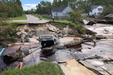
The water rose faster and higher than anyone had anticipated. Hal Lowder, Jr., recalled watching Hurricane Florence’s impact arrive in Whiteville, where he is the city’s emergency services director. “It was all swamp on Madison Street,” he said. In low-lying areas that might flood two feet in a big storm, water was more than 12 feet high. Even downtown, on Main Street, some areas had eight feet of water. “It was over my head. It was just bizarre.”
The coastal plain of North Carolina was hit hard by the hurricane. The 911 call center was down, and the police and firefighter radio system was inoperable. But there was no loss of life in Whiteville, thanks to the dedication of emergency responders and to the communications systems they had in place.
One of the reforms that came out of the 9-11 Commission was an effort by the federal government to bridge gaps in emergency responder communications. FirstNet is a nationwide public safety broadband network, a service of the federal government provided under exclusive contract with AT&T. Whiteville, seat of Columbus County, was the first city in North Carolina to sign up for FirstNet.
While it’s not yet available everywhere, FirstNet has become part of the critical information infrastructure of emergency communications. And there’s reason to hope that as it’s built out, it will lead to greater connectivity in parts of the state that currently lack even reliable cellular service.
Red Grasso serves as the state of North Carolina’s point of contact on the FirstNet system, liaising between local communities, the state, and the federal government. “FirstNet has been a tremendous catalyst over the past five years to bring public safety to the forefront of the conversation,” he said. Before the system came online, he said, “a lot of conversations about cellular connectivity, about internet access, were about its commercial application.” Public safety was an afterthought. “FirstNet has flipped that conversation to, ‘Let’s address public safety’s needs and then we’ll figure out how to commercialize it.’”
First Net’s successful application in North Carolina, and the contrasting experience of communities that don’t yet have it, demonstrate how vital resilient, real-time communications are to saving lives in an emergency. That means having access to modern broadband infrastructure.
Like most every city in America, Whiteville depends on the internet to function. Its new city hall is wired with cable broadband, the phone system is Voice over Internet Protocol (VoIP), and data live in the cloud. “I can log in from home from my truck, my command post, my command vehicle. Log in from city hall. But if we lose internet, we’ve lost everything,” Lowder said. “We live in a virtual world now, so we have to have connectivity.”
Those of us who rarely interact with emergency services likely don’t realize how complex a problem it is for different agencies to gather and disseminate information. Firefighters and police use mobile data terminals to communicate from their vehicles. Ambulances send cardiac monitor data as they speed toward emergency rooms. Police log into mobile data terminals in their cruisers. Yet, even with these technologies in place, our emergency responders still rely on technologies like point-to-point radio.
Providing connectivity during a disaster requires a complex network of systems that can include fiberoptic lines, cellular data transmission, and radio. Any of these systems can fail in a hurricane or other disaster. That’s why a resilient system is made up of multiple networks.
Months before Hurricane Florence, Lowder had moved the city’s public safety communications over to FirstNet after noticing that the ISP serving his department was throttling its public safety data.
“When Florence hit us, other carriers–Verizon, AT&T, US Cellular–were so overwhelmed, nobody could talk,” Lowder recalled. “We noticed that even people out in the county couldn’t talk on their phones. They couldn’t push data on their terminals. But everybody who worked for the City of Whiteville was working. Our little hot spots were working. My phones were working. We were the only game in town that was actually communicating on wireless.” The team made approximately 100 water rescues during Florence. Without connectivity, the outcomes might not have been so positive. “We would have gotten creative, and I guess handed out sticky notes or had rescue teams report back to the command post to get their assignments like we did in the old days. That would have really slowed down our response times.”
Access to Modern Internet is Essential for Public Safety
For those tasked with informing the public about evacuation routes and emergency relief, access to modern internet-based communications is essential. Fortunately, North Carolina’s history of investment in high-tech infrastructure has paid off.
“North Carolina has been extremely good about leveraging digital assets in emergencies,” said Kirk Ross, a journalist who reported on both Hurricane Matthew and Hurricane Florence for the Washington Post. He relied heavily on the state’s Flood Inundation Mapping and Alert Network, or FIMAN, which offers flooding predictions using real-time data on stream elevation, rainfall and other weather indicators gathered from more than 550 gauges across the state. These data enable emergency responders and rescue crews to determine nearly in real time when a neighborhood will become inaccessible, and they help prioritize rescues. Likewise, the Traveler Information Management System, or TIMS, provides real-time information on severe and unusual congestion on all roads maintained by the North Carolina Department of Transportation. “In the last storm, that system was super accurate and timely,” Ross said.
Having access to this information helps people plan ahead, Ross said. “They can look at this mapping system and say, ‘If we get five inches of rain, we’re in trouble, so we should just go ahead and leave now.’ Evacuations can be more orderly, and people can get the information themselves rather than waiting to hear it on bullhorns from somebody driving through the neighborhood.”
Ross used both services when reporting on the hurricanes, not just as sources for live social- media updates but also as guides to where he could report from safely. “I was on my way down to Wilmington and had a route picked out, Highway 421, because I’d talked to a reporter who said, ‘This is the back way in right now. This is the way everybody got in yesterday.’ Well, an 18-foot hole developed overnight, and I was just about to get in the car and I thought, ‘Well, let me just check this route.’ And sure enough, even before Twitter had that 421 was down, you saw it on the DOT site.”
But none of this information is useful if you don’t have broadband access or enough broadband capacity to rapidly download data as conditions change.
In Beaufort, Mayor Rett Newton watched the storm surge and faced a daunting challenge: how to communicate with those residents who, for whatever reason, had not evacuated. “They need to know what is going on in town – do we have a curfew in effect? Where can people find food and water and gas?”
Unfortunately, his options were limited. “On hour two of day one of Hurricane Florence in Beaufort, we lost power,” he said. The town’s email server went down, as did its website. “We lost internet. We were essentially limited to text and phone calls.”
Even on a sunny day, broadband access is a challenge in Beaufort. Town systems run on a cable network, yet many residents of Carteret County lack high-speed internet access to their homes and businesses. Newton regards this service as “part of the infrastructure of growing jobs.” He said the town is working to remedy its limitations and ensure that communications are reliable when the next storm hits. “We’re looking very hard at how to get broadband to the community, and will it be sustainable in a storm?”
Newton said that as once-rare weather events become more frequent, it’s that much more important to solve the problem. “If and when the next major storm comes here, we’ve got to be able to communicate with people who have evacuated and those who’ve decided to stay,” he said.
Would connecting to FirstNet help solve Beaufort’s problem of lack of broadband availability?
To some extent, it could, Grasso said. FirstNet is a separate network from AT&T’s commercial cellular network, but they share infrastructure: where there’s FirstNet coverage, there’s also AT&T coverage. The company’s contract with the federal government offers an opportunity to build infrastructure in areas where there hasn’t been a business case to provide commercial services. If FirstNet creates an infrastructure of towers and other equipment in underserved areas, then AT&T and other carriers could piggyback and begin to offer commercial broadband service.
“I think that FirstNet will serve as a catalyst in rural areas, where there’s less population density,” Grasso said. “It’ll end up being a catalyst for other broadband usage outside of public safety.”
The Technology is There, We Need the Broadband to Catch Up
Although it is a far cry from fiber-to-the-home, access to mobile phone service is essential to responding to natural disasters.
Out west in Nantahala, Franklin, and other remote, high-elevation areas of Macon County, you won’t get a cell signal, whether you’re a hiker on the Appalachian Trail or a paramedic monitoring vital signs. Warren Cabe, Macon County’s emergency services director, said FirstNet would be a welcome improvement on the status quo. Emergency responders there currently rely on a point-to-point radio system that transmits voice only, not data. And that system relies on towers that can transmit signals only to limited geographic areas. Users have to change frequencies as they move through the area in order for their calls to reach the nearest tower.
“Imagine going down the road, and you’ve got a list of cell phone towers, and you have to pick the tower you want to use in order for your phone to work,” Cabe said. The county is in the process of installing equipment to allow signals to bounce from tower to tower, so people on different sides of a mountain can talk to each other.
Despite these limitations, Macon County has used technology in remarkable ways to help residents cope with disaster. In 2004, remnants of hurricanes hit an area called Fish Hawk Mountain, causing mudslides that obliterated homes throughout the valley. Cabe and his colleagues layered topographic maps via a geographic information system (GIS) creating a 3-D image that simulated mudslides and showed where structures used to be. That information helped with damage assessments related to insurance claims, so residents could get the help they needed. The team did this work without connectivity on site; they gathered data with their laptops and brought it back to the office. It’s another example of how technology and its applications have leaped forward even while broadband access drags behind.
Cabe recognizes that Macon County’s mountainous terrain makes broadband infrastructure challenging. He added that the county is ready and eager to share its resources with providers, including AT&T. “We already have vertical assets. We’ve got towers, we’ve got buildings. We’ve got some infrastructure in place in areas where service would benefit communities.”
He anticipates that connectivity may require a mix of networks, including fiber optic and wireless internet service providers (WISPs). “I don’t know that there’s going to be one solution that will fix all of Macon County,” Cabe said. “I think personally that it’s going to have to be a hybrid version of a lot of different technologies to resolve these issues.”


